
The Kansas Green Thunderstorm of 4 October 1998
(published in Bullentin of the AmericanMeteorological Society, March 2002, P.355-357)
Pao K. Wang
Department of Atmospheric and Oceanic Sciences
University of Wisconsin-Madison
Madison, Wisconsin 53706
This note is motivated by a stimulating invited seminar entitled “ Green Thunderstorms” in the author’s department that Craig Bohren gave on April 16 this year. As Craig pointed out in the seminar and in a joint paper he and Alistair Fraser co-authored (Bohren and Fraser 1993), photographs of green thunderstorms are rare because these storms are infrequent and potential photographers are more likely to be seeking shelter than exposing themselves to torrential rain. In a related paper, Gallagher et al. (1996) provided spectrophotometer radiance measurements of green and non-green thunderstorms, but did not include a photograph. The author happened to be lucky (or unlucky, in the sense of being trapped in the weather.) While witnessing such
a storm, he had a camera in hand, unlike Craig on 5 June 1991.
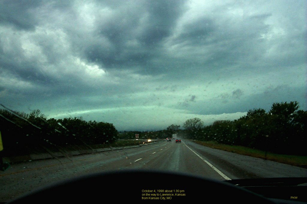
The green thunderstorm, shown in Fig. 1, was photographed by myself on 4 October 1998 when I was invited by Kelvin Droegemeier to give a talk in the Aviation Weather Hazards Study Conference Workshop held in the University of Kansas at Lawrence. I arrived at the airport in Kansas City, Missouri, rented a car, and started driving toward Lawrence (i.e., due almost directly west) on Interstate 70. The flight was bumpy and the sky was cloudy with altostratus but not very dark when I started driving. After about 30 minutes, though, the sky darkened and a huge storm system appeared above the horizon ahead. There were sprinkles of rain but not torrents, and the road was wet, as can be seen in the photograph. It was difficult to get a good estimate of the distance of the storm system, but it must have been at least 20 miles away, as heavy rain started a short while after I had arrived at Lawrence. The storm looked like a giant mushroom, with the stem of the mushroom extending much further both to the left and to the right of the photograph, subtending an angle greater than 90 degrees over the horizon. Patchy low stratocumulus clouds stretched outward like a huge umbrella and were darker than the stem of the storm. The color of the stem was what made it special—it appeared to be a column glowing green inside but enveloped by a translucent whitish outer layer. As pointed out by Bohren and Fraser, blue and red overhead are the norm; green is not. A green sky gets attention; it is a source of wonder and even fear. The green storm system I witnessed was not overhead but rather ahead, yet it was no less impressive.
The green color in Fig. 1 appears to be consistent with my memory, although at the time the green in my memory appeared to be brighter than shown here. But, of course, human memory (including the author’s) is notoriously inaccurate in brightness assessment, and I might have been simply impressed by the unusual green tone. The green color was not intense as that of emerald but was lighter green like a patina. The picture was taken using a Kodak DC-260 digital camera at its highest resolution. I have not made any color corrections or other adjustments, so the photograph is printed as it was taken. But, of course, it is also possible that the printer might not have reproduced exactly what one sees on a computer monitor (and the views on the computer monitor are influenced by the brightness settings).
I did not record the time when the picture was taken, but my rental car receipt indicated that the time of car rented was 1:27 pm. Since the picture was taken somewhere between Kansas City and Lawrence (about 50 miles from Kansas City), the time of the photograph must have been around 2 pm, give or take 10 minutes. This seems to fit the situation portrayed by Bohren and Fraser (1993) in their Fig. 11 where the sun is higher in the sky. Thus this was not a typical green thunderstorm, which is seen at low solar angles. But it indeed fit the criterion of a large thunderstorm system that produced the green color.
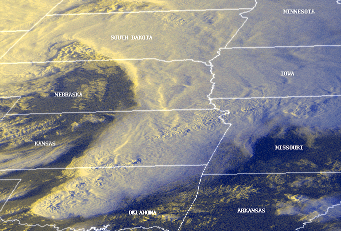
Fig. 2 shows a GOES satellite image of the 4 October 1998 thunderstorm system taken from the NOAA Operational Significant Event Imagery (OSEI) website (http://www.osei.noaa.gov/). There is little doubt that this was an intense and large storm system, as evidenced by just inspecting the satellite image. It turned out that the two opening keynote speakers for the conference, General Fred Lewis of US Air Force and Mr. Warren Qualley of American Airlines, were unable to arrive at Lawrence because of the severe weather. The opening ceremony of the conference was held in the evening in the Malott Room of Kansas Union at the university. One side of the room was fitted with a big glass panel so that guests in the room would get a wide view of the campus. During this ceremony, instead, the conference attendants got an astonishing view of the lively thunderstorm show going on outside. At some point in the middle of the ceremony, a powerful lightning bolt knocked out the power supply and the room became pitch black. The attendants were left to appreciate the brilliant lightning display and rolling thunder, a very fitting natural setting indeed for the opening ceremony of an aviation weather hazards conference.
References
Bohren, C. F., and A. B. Fraser, 1993: Green thunderstorms. Bull. Amer.Meteor. Soc., 74, 2185-2193.
Gallagher III, Frank W., William H. Beasley, and Craig F. Bohren, 1996: Green thunderstorms observed. Bull. Amer.Meteor. Soc., 77, 2889-2897.
List of Figures
Fig. 1. The green thunderstorm of 4 October 1998 photographed by the author while he was driving toward Lawrence , Kansas, on Interstate 70. The road is pointing to the west. (bottom picture)
Fig. 2. NOAA GOES-8 channels 1, 2, and 4 composite image of the 4 October 1998 storm system in the Plains. (NOAA) (top picture)
posted by Pao K. Wang | 3:44 PM
![]()
![]()
0 Comments:
Post a Comment
Subscribe to Post Comments [Atom]
<< Home